Growing, planting and promoting
Florida native plants for sustainable landscapes.
Gardeners & Homeowners Florida native plants for sustainable landscapes.
Visit PlantRealFlorida.org
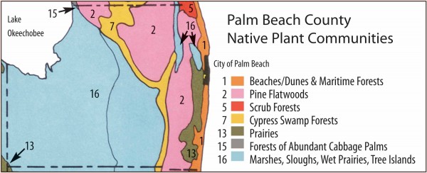 Detail from UF/IFAS Davis Vegetation Map of Florida, showing the plant communities in Palm Beach County.
The Plant Communities Map used on this website is directly adapted from the original “General Map of Natural Vegetation of Florida” developed by John Henry Davis, University of Florida (UF), and published in 1967 by UF’s Agricultural Experiment Station, Institute of Food and Agricultural Sciences (IFAS), in Gainesville, in their Circular S-178. The map was subsequently used for Florida ecology classes at UF for many years. UF Graduates from the 1960s, 70s and 80s may recognize the map. Digital reproductions are available from the University of Florida Digital Collections Library. Earlier versions of this map exist, in particular Davis’ Vegetation Map of South Florida from 1943; and a variety of modified versions exist with other organizations as well.
The Davis map is one of many available vegetation maps for Florida, but one which FANN thinks strikes a pretty useful balance between simplicity and complexity when it comes to using it as a tool for plant selection. FANN incorporated the map, with modifications, into our 1991 book, Xeric Landscaping with Florida Native Plants, and of course this website as well as our consumer site, PlantRealFlorida.org
John Henry Davis (1901-1978?) was a prominent Florida botanist perhaps best known for his groundbreaking study of Florida’s mangroves and mangrove swamp systems, mapping the Florida Everglades, early promotion of the importance of beach dunes and their development and maintenance and consultation to the infamous and fortunately ill-fated Cross Florida Barge Canal. Davis went to high school in Eustis, Florida, spent his college summers here, married a woman from Orlando, and after earning a Ph.D. in Ecology at the University of Chicago (part of an early class in this subject), returned to Florida permanently in 1941. His work with the Florida Geological Survey and UF took him all over the state, and thankfully for us, resulted in a greater understanding of our state’s native plant communities.
FANN would like to see the map moved into the 21st century so that industry can take advantage of digital technology to enhance its usage. Michael Miller, of Perfect Island US, a Florida landscape designer with experience using FANN’s plant selection framework based on the map, actively works to promote the maps use and enhancement through hands-on experience and modern technology. We appreciate Michael’s enthusiasm and work, and look forward to his future innovations in this area.